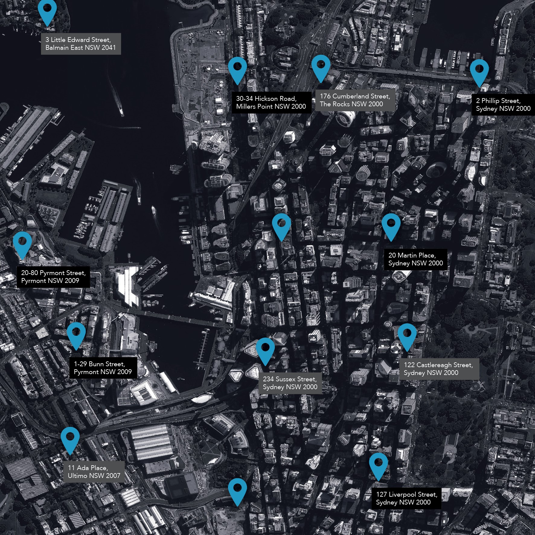
The G-NAF dataset contains all physical addresses in Australia.
It’s the trusted source of geocoded address data for Australia. Over 50 million contributed addresses are distilled into more than 15.2 million G-NAF addresses.
G-NAF is built from addresses supplied by 10 contributors, including the land agencies in each state and territory of Australia. The source data is:
- Independently examined and validated.
- Matched textually and spatially.
- Assigned a geocode to place the address on a map.
Download G-NAF product description
View the G-NAF Metadata statement
Download the Quick Reference Guide – Unpacking G-NAF
G-NAF Core
Geoscape also offers G-NAF Core, which reduces the complexity of G-NAF by delivering the data in a simplified table model. It provides the core richness and power of G-NAF in a comprehensive, but easy-to-use format.
Click here to learn more about G-NAF Core and to download the dataset.
Get in touch with us
G-NAF helps answer everyday questions about location.
Policy and Services
Develop more accurate socioeconomic and demographic trend analysis for policy development and service delivery.
Profiling
Build profiles of suburbs and wider areas by combining G-NAF data with social, demographic, economic and environmental data.
Emergency Management
Identify and map areas under threat, recognise evacuation routes, and direct emergency services first responders.
FAQs
G-NAF (Geocoded National Address File) is recognised as the most requested high-value dataset. It contains address data including the state, suburb, street, number and coordinate reference (or “geocode”) for street addresses in Australia. What makes G-NAF unique is the rich data associated with each address including the linking of official addresses with in-use addresses, linkages to other datasets including ABS data and rankings based on input from multiple contributors.
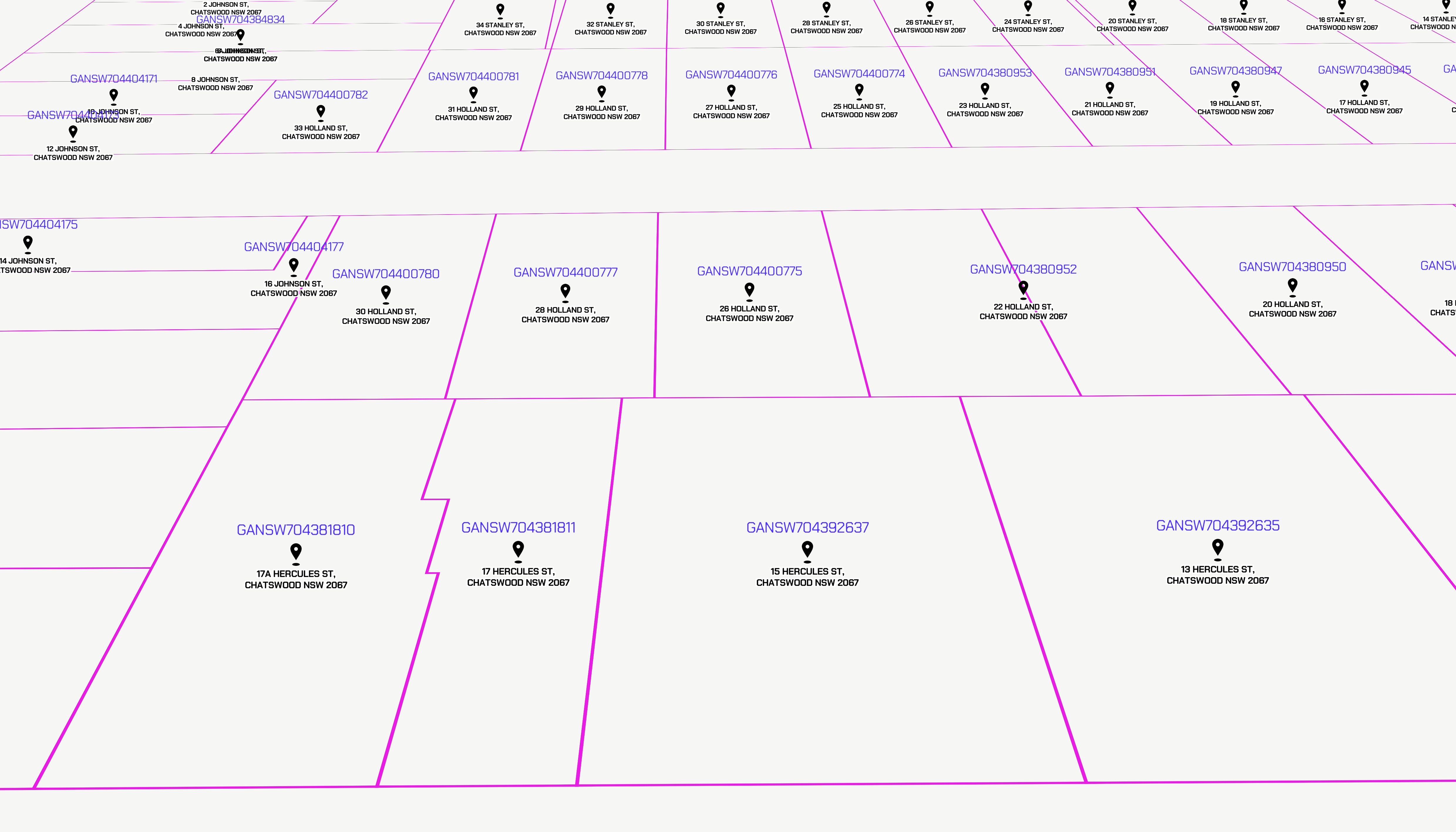
G-NAF is a complex dataset combining data from multiple sources into one comprehensive dataset. Metadata for each of the 15.2+ million principal addresses enhances the usability of G-NAF. This metadata captures:
Principals and aliases
Addressing is complex and sometimes the same property might be identified by multiple address labels. For example, an apartment block may be listed as 5–7 Smith Road or 5 Smith Road. Or 1A and 1B can be confused with units 1 and 2. The G-NAF production process identifies these relationships and links the addresses people use with official addresses created by governments. The address provided by the government custodian is generally considered the principal and any other addresses are known as aliases.
Geocode
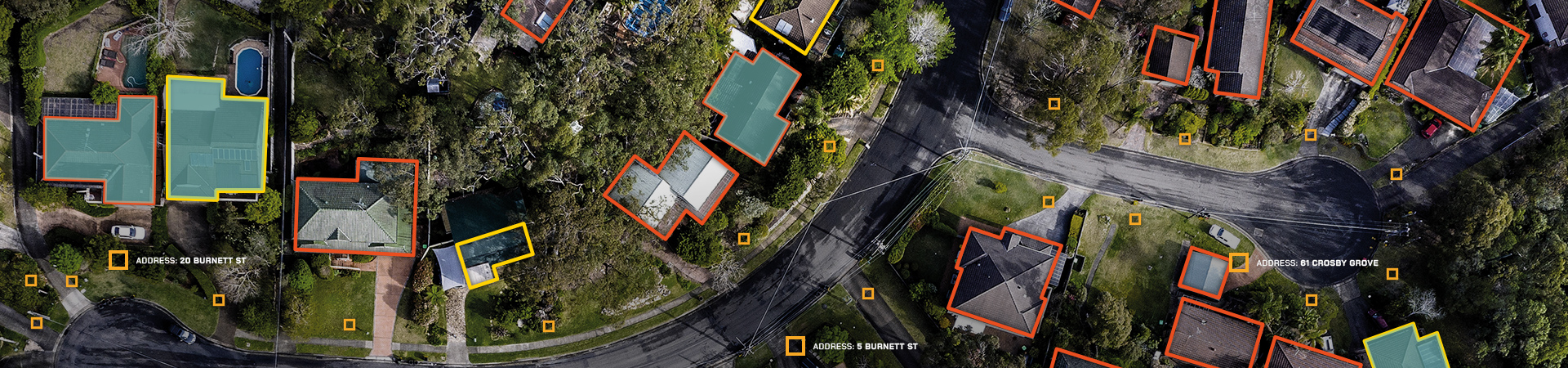
This is a set of coordinates – longitude and latitude values – that enable the location of an address to be shown on a map. A geocode facilitates analysis, such as calculating the distance between the address and another point. Or understanding if an address is inside a catchment or risk area. Or find the nearest delivery vehicle for job allocation. All addresses in G-NAF have coordinates. For over 96% of addresses (including aliases), the geocode places them inside the associated property boundary.
Mesh block identifier
A mesh block is the smallest geographic region used by the Australian Bureau of Statistics. With a mesh block ID attached to each address in G-NAF, addresses can be linked to relevant demographic and socioeconomic data.
Confidence levels
Each address is given a confidence level to indicate how many contributors support it. Not all contributors are exposed to all addresses. For example, jurisdictional addresses may not cover all private estate and complex addresses.
If an address is no longer supplied by any contributor, it is given a negative rating. These addresses remain accessible in the dataset for specific use cases.
Primary and Secondary
Addresses that contain sub-addresses, for example, a block of units or townhouses, have flags to denote the primary (e.g. 10 Smith Street) and secondary (e.g. Unit 6).
Unique persistent identifier
Each G-NAF address is allocated a unique identifier, or G-NAF PID, which persists with the address label in the dataset. This enables information across different systems, departments or organizations to be shared based on a common address. Should the address label change, a linking relationship between the old and the new address is provided in the dataset.
Addresses are created or changed by various authorities. These addresses need to make their way through the relevant processes, including various levels of government, before they reach Geoscape as a contribution to G-NAF. Geoscape receives addresses from contributors on an ongoing basis and feeds them through a 13-week production process. The cyclical production process means the currency of an address can vary between 2 months to 6 months upon the release of G-NAF.
There are three ways to access G-NAF: Geoscape wholesales the product to our network of value-added resellers and integrators who take G-NAF to market as a raw dataset, as part of a software solution or part of an integrated solution, including consultancy, to tailor the product to your specific requirements. The Australian Government releases G-NAF, along with Geoscape’s Administrative Boundaries, under open data terms through data.gov.au. GNAF address data is utilised in Geoscape’s address API services
G-NAF is produced from data provided to Geoscape by contributor organisations. If you would like to add or change an address, you will need to contact your local government or state land agency. In some cases, we may be able to provide some assistance.
G-NAF does not contain any personal information or details relating to an individual or business.
An address not appearing in G-NAF may be the result of any of the processes at either the contributor or Geoscape end of production. If you would like to check the inclusion or exclusion of an address, please contact your local government or state land agency.
G-NAF contains addresses for physical locations. For an address to be included in G-NAF, it must meet pre-defined criteria for what constitutes a valid address. For example, addresses with no street numbers are not usually included in G-NAF.
Geoscape receives over 38 million addresses each quarter from 10 contributors, including state and territory government land agencies and Commonwealth sources.
G-NAF is produced from data provided to Geoscape by contributor organisations. If you would like an address removed from address records, you will need to contact your local government or state land agency.
No. G-NAF contains addresses for physical locations, not postal locations. Please contact Australia Post to confirm your address is correctly recognised by the mailing system.
No. An address does not necessarily mean there will be a building there. Addresses are used to not only label land parcels, properties and buildings, they’re also used for locating a variety of assets such as ATMs, tree plantations, reserves, parks and utility substations.
Geoscape makes G-NAF available in a zip file of up to 3GB in size, containing more than 30 tables of address data that need to be uploaded into a relational database to form a national dataset. Please see the G-NAF product description for more details on the formats and structure of the dataset.
G-NAF contains addresses for all states and territories of Australia including external localities such as Christmas Island, Cocos (Keeling) Islands and Norfolk Island.
G-NAF has a quarterly update release cycle occurring in February, May, August and November each year.
Previous releases may be obtained from Geoscape partners.
In most cases, yes. Exceptions relate to when there is a significant change to an address. In such cases, the address record will be retired and a new record (with a new PID) will be entered. Changes to any of the following parts of an address may lead to a change in the PID: flat number, street number, street name or type and/or locality name.
Geoscape cannot advise whether G-NAF will meet your specific requirement. We can advise that every address in G-NAF is contributed by an organisation that manages this information as part of their ongoing core business. You can be sure all addresses included in G-NAF are ‘in use’. However, G-NAF does not contain information that will confirm if a house or some other form of building/structure exists at that location.
There are over 15.2 million addresses in G-NAF with more than 50,000 addresses added each release.
Geoscape partners provide a range of commercial products based on G-NAF including off-the-shelf and bespoke software solutions, consultancy and support.
G-NAF Core is a simplified version of the G-NAF dataset. It has been designed to provide a more consumable list of Australian address data. It minimises the requirement to select fields and build data relationships to access the essential address data contained in G-NAF.
Get G-NAF
Geoscape Authorised Partners
The dataset is also available under licence from Geoscape authorised partners.
Additionally, if you are looking at building next-generation solutions for your customers, our partner program may be a perfect fit.
Unlock the power of spatial data by choosing the right partnership for your business.
Download for free
Download for free at data.gov.au.
Formats:
- Pipe Separated Value (*.psv)
Case Study - ACT Emergency Services
When you call 000, you want an emergency services vehicle to find you quickly. Accurate address data in G-NAF has enabled ACT Emergency services to do that for 15 years.